Marvelous routes of Potamia
The road of the Pilgrims
On our way we will meet many typical evritanian villages such as the historical Koryschades, the cute Voutiro and Nostimo, the beautiful Mikro and Mega Chorio, which most of the have a remarkable tourism infrastructure. There we can stop for a coffee under the shade of plane trees, to taste the local cuisine and enjoy a drink before the sun sets. Leaving Karpenissi the first village you will meet is the picturesque Gorgianades perched at an altitude of 900 m. Continuing on the main road of Potamia on the left we find the church of Panagia of Mesabelias, dedicated to the Assumption. This church is the only remnant of the monastery that was destroyed in 1821. The locals built a whole new church. A portable icon of of Ag. Tryphon of the 18th century is extremely interesting.
On the main road is the riding park. With trained horses you can enjoy walks along the Karpenisiotis river and the wooded slopes.
A crossing to the right leads to Koryschades, one of the most historic and beautiful villages of Evritiania. Its name preoccupied researchers and some of the attribute to the ancient word Korys – ancient helmet and associates it with the location Kaminia which is said that in ancient times the villagers were making weapons and items. Others link the name of the village with the word Korona that means crown and others with the verb korysso meaning supply.
On the nearby hill of Paliokastro you will see the remains of the old fortress walls, while in 1954 many old graves, houses and objects of copper and brass found in Kaminia. Remarkable is the village school that was built in 1901 by private initiative. At that school the first Greek Parliament of the first free elections met in May 1944, with the participation of 176 representatives from across the country. By the end of this meeting, the Parliament adopted the resolution “all powers emanate from the people and exercised by the people.”
The school has declared a historical monument and houses the Museum of National Resistance with a photography exhibition, the work of famous photographer Spyros Meletzis.
Walking through the village you will meet many old rich houses and the church of Ag. Athanassios built the 1865, which celebrates on the 29th of June. Just outside the village, in Koumasia, will see an old monastery of 1650, which you can reach by walking the road that starts from the square of Koryschades, following an easy and beautiful drive. Returning to the main road to continue our acquaintance with the region, a detour leads to the village Klafsi, with the significant post-Byzantine church of Ag. Leonides. At next intersection we will reach Voutiro, a classic evritanian village which has the the largest church in the county dedicated to Ag. Paraskevi, built in Byzantine style in a stunning location.
Voutiro has fine houses, rich fruit and vegetable production and livestock products and many emigrants, who always remember and help the picturesque village. According to tradition, the name derives from Ali Pasha tasted delicious butter in the village.
At an altitude of 800m. at the foot of the mountain Kathara we meet the next village, Nostimo. Although the official version of the origin of the village name indicates that it was named by the homesickness of the emigrant population, still there is another story that connects it with Ali Pasha as well. So, according to tradition the Pasha met a beautiful “tasty” village girl and gave that name to the village. In the village you will admire the old watermill and the Rico, a the stone arch bridge. From Nostimo two forest roads start. Following this direction and after 30-45 minutes of pleasant hiking on top of Korona we will have a beautiful panoramic view of the surrounding villages.
Another forest road leads to wonderfull Mikro Chorio (after about 45 minutes of hiking) and Mega Chorio. For now, you will turn right towards the Mikro Chorio. The new Mikro Chorio was built by a mountain village design and is found two kilometers before reaching the old Mikro Chorio, through the dense fir forest. The New Mikro Chorio is truly an unexpected architectural gem of Evritania.
After a stop in the beautiful square you will follow the road to the Old Mikro Chorio. Here, a huge part of the mountain landslide in January 1963 and the spring months forms a beautiful lake which is worth photographing. At the square of the village you can cool off by drinking water from its 5 picturesque fountains. Also you will see the church of Ag. Kyriaki, while at the old school and the museum you will see interesting photographs of the landslide, newspaper clippings about the resistance, furnitute and documents from of the Office during the Occupation from the Nazi. Also, the museum houses traditional folk art objects and some ancient finds of the area. Also the church of Sotiros where the famous Markos Botsaris prayed and you will find the spring named by him.
In Ano Logkoves area will see the monument for the execution of 12 Greek hostages by the Nazi in the Second World War.
Leaving the beautiful small village we meet again the main road. On the opposite side stands the majestic Mega Chorio for which you will turn left. The village is the seat of the municipality Potamia. It has many picturesque streets and has a strong tourism industry. the chapel of Ag. Athanassios just before entering the village predisposes for the charm of the area. With leafy trees, small wooden bridges and melodiously water the route is really magnificent.
Right at the entrance of the village, we can follow the marked path to the source of the waterfall. With leafy trees, small wooden bridges and melodiously water route, the place is really magnificent. The forest surrounds Mega Chorio and abundant water adds to the coolness of the summer. The picturesque stone houses retain their traditional character while the trails pass near the stream with small waterfalls and wooden bridges. In the village you will find the old church of Ag. Paraskevi, built 150 years ago, and also the Byzantine style church of Ag. Gerasimos the Megalohorites the Younger, who was martyred in Constantinople on 03/07/1812. The church was built in his honor by the vibrant and progressive “Association of Megalochoriton Agia Paraskevi”
Extremely interesting is the Folklore Museum that hosts traditional costumes, household items and traditional creations. Traditional sweets and evritanian products will find in Mega Chorio and Gavros. Finally, if you are in Mega Chorio in summer, do not forget to attend the fair of Panagia Prousiotissa which settles in Gavros in the 23th of August.
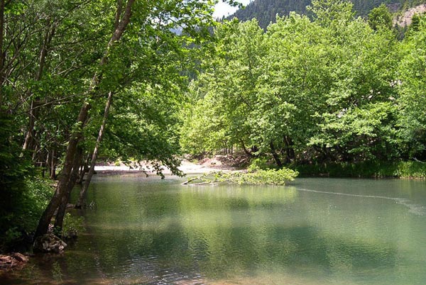
To get to the Gavros village you should return to the main road and walk or drive the road that begins from Mega Chorio. At Gavros at earlier times the pilgrims who were going to the Monastery of Proussou used to stop for a while. Today during hiking is an ideal spot to rest and enjoy good food in a magnificent location, with bridges over the Karpenisiotis river. In the waters of the river operates a trout farm. You can can try the delicious fishes an the taverns of the area.
A short detour from the main road leads to Karitsa. In this village, and next Dermati, the locals carrie soil to make cultivable terraces for corn, vines and various fruit trees. Also there is remarkable canyon Vothonas which you can walk through in 5-6 hours. After Dermati you can continue to Chelidona Mountain, where have ancient copper mines came to lightm likely to supply the necessary raw material for the manufacture of weapons of Koryschades residents. Continuing our way to Prouss, you will enter to a small canyon. Here you will find the impressive Kleidi location where a massive rock is standing just over the passage of the road. At the end of the mountain ridge, on the right, we see the “Typoma”. It is said that from this point passed the icon of Panagia Prousiotissa at the period of the iconoclasts, to find refuge in the cave at the present monastery of Proussos, where a monastery and church was built.
Lower on the rock above the small cave – chapel with the icon of the Virgin Mary we see a curious -and for many unexplained- geological phenomenon. On the vertical rock seven different color schemes in the form of strokes are shown. Τradition has given the name “Footspets of the Virgin Mary”.
Τradition states: The Evangelist Luke during the period that was on Patmos island, he painted along with other icons and the icon of the Virgin Mary that is now in Proussos. For many centuries, the icon was offering miracles at a large temple in the Proussa of Ionia, Mikra Asia. During the period of iconoclasm, in 829 AD a person named Dionysus took the icon and brought it to Greece, in order to escape from the disaster. Somewhere in the path he lost the icon which was mysteriously found in the cave where today by a few shepherds, who for days were seeing a mysterious light column indicating the cave. Dionysus heard that the icon was found somewhere close to Karpenissi, went and took it back. As he returned to his escort fell to sleep. This morning the picture was gone and a mysterious voice told them that the desire of the image was to remain in the cave. During its return, the Virgin Mary passed the point of “Patimata” (footsteps) and crossed the mountain, which took the form of the her image.
The silver cover of the icon was donated by the famous Georgios Karaiskakis to heal from a sickness that tormented him and because of which he used to stay many times in Prouso for recovery. Shortly before we arrived at the monastery we find two fortified stone houses, the east and the west tower of Karaiskakis that, as they say, were built to protect the hero of the revolution during his recoveries in Proussos.
Arriving at the Proussos, established in the early years of the 9th century, the landscape is presented to us with awe and respect. By walking the few hundred yards you will reach the sacred site. Dug into the rock of the church Prousiotissa, it welcomes us, silent and majestic in the simplicity. We will admire the old icons and we will pass through the small space inside the rock where the icon is protected by glass.
The Monastery’s interesting museum exhibits remarkable icons of the 15th and 16th century, vestments, gold and silver chalices, manuscripts, printed books and the sword of the hero Georgios Karaiskakis. Among the exhibits are two stand out fabrics embroidered with quotes from the Koran. Opposite the monastery stands the church of Ag. Panton built in 1974. You can also visit the Clock Tower of the monastery that is perched on a small hill, measuring time, in a place where time has no meaning.
Leaving the monastery you will continue to the beautiful village of Proussos. Here a stop in the main square is required. The Agathideios library with rare editions of Leipzig and the Katsameio Gymnasium are two significant sights of the village. Proussos has many taverns and grills with traditional delicacies.
If you love sports you will hike up to the Mavri Spilia (Black Cave), located on the opposite edge of the village of Proussos and is about half an hour walk from the road, through a path full of ponds, streams and lush environment. It is also called Apokleistra because it has two entrances, one from the village and the other is outside the settlement. The cave was a refuge for the inhabitants in the years of the war with the Turks, especially for the wifes and children of the warriors, ammunition and supplies. Even people from the beleaguered Messolonghi in 1824 and found shelter.
Many visitors stop in Proussos and take the road back. But the surrounding area offer beautiful surprises to those who decide to get to know it. Within walking distance you will reach Kastania village where you will see eight interesting churches, while the road reaches the Prodromos. On the other side, the road is leading to the villages Koulio, Esochoria and Aspropirgos and the settlements Vrysoula and Parigoris. In a short distance from the villages is the location of “Polemos” (war), where many objects of the old ruined village were found.
The road continues to the village Velota. It is worth taking a stroll in the picturesque chapel of Ai-Lias, to stop for a walk and picnic on the riverside or enjoy your meal at the picturesque village café. In Velota there is also the traditional small village Velotoula, a real jewel of the region. Small soil roads are leading to the next villages Sarkini, Stavrochori, Isomata and Katavothra.
Katavothra belongs to the Municipality of Proussos. The main village is situated at the foot of the Sierra Panaitolikos, in altitude of 680 meters. It is surrounded by high mountains of 1400m to 1800m elevation.
On the rails of the Gauls
On this route we will follow the perimeter road of the northern edge of Kaliakouda Mountain and meet the beautiful villages of south east Evritania, including Krikello and Domnista. If you want to return the same way you can make a little trip to a soil road – a unique natural beautiful landscap and arrive through the villages Sygkrello and Aniada to Klafsi, where you can admire its unique early Christian monument.
Leaving Karpenissi follow the road to Ag. Nikolaos. A small sign on the right leads to Myriki, a quiet village with the church of Prophet Elias in a serene plateau at the top of it. In the center of Myriki visit the church of Ag. Georgiou built in 1898.
Continuing towards to Ag. Nikolaoss, the first totally green village we meet while going down from the Rachi of Velouchi (coming from Lamia). It is 9 km away from Karpenissi, built amphitheatrical in a wooded area surrounded by chestnut trees, plane trees, nut and fruit trees. In winter the village square usually has snow. If you are there during this period it is and ideal suggestion to try the local drink “tsipouro” and baked chestnuts on the fire. The site houses the church of Ag. Nikoloas of Vounena built in 1887 that was formerly the convent of Virgin Mary and which was destroyed a few years before the 1821 revolution. Also, the whole village was destroyed by fire from the occupying troops of Nazi in the years 1943 to 1944 but the houses were rebuilt and regained its previous charming form. From the village square a road begins for about two kilometers to the northwest, which leads through the dense forest of firs in the chapel of Ag. Paraskevi built in 1850. Ag. Nikolaos is famous for its rich production of chestnuts and beans. Near the village the places Krania, Nerakia, Trifyllies and Gyalos have untapped sources of sulphurous water and lands of unexplored coal deposits.
After Ag. Nikolaos, the road leads to the south across beautiful fir. About halfway to Krikello do not miss the signs for the historic site Kokkalia (bones). We take the turn and climb a smooth road. In this plateau there is a commemorative monument of the battle that took place in 279 BC where the united Evritans and Aetolians defeated the Gauls of Vrennou. Due to the many human bones that were constantly found (until a few years ago) the locals named the village.
Taste the cold water from the spring and continue the road to Krikello. At 1120 m. elevation you reach the beautiful village. The majestic mountains standing green in summer and snow in winter. The Evritan poet and novelist Zacharias Papantoniou wrote the “Symphony of the Mountains” describing the magnificent landscape you will see. Old trails for warriors (kleftes) and captains, lead to unique locations among dense forests of ancient trees, holly, rare herbs and shady trees bathed in the waters of the beautiful Krikellopotamos river. Upon entering the village we see seven sprigns providing very cold water running from the marble mugs. The church of the village, Ag. NiKolaos is one of the most beautiful of Evritania and is located in the central square of the village full of dense trees.
The next village we meet on our journey is Domnista which is a large village with many visitors and many archaeological finds and is built on 1000m. he ancient Fantinos was the most important point during ancient times. Its unexplored archaeological site is located under the church of Virgin Mary (Paliokklisi). In Domnista, in the village square, on June 7, 1942 Arus Velouchiotis officially declared the armed struggle of the Resistance during the Nazi occupation. Every year on the first Sunday of June, many events take place at the Monument of National Resistance. The Folklore and History Museum hosts many antiques and rich archival photographs of the area from various periods in the history. Very interesting as well is the church of Ag. Athanassios built before 1900.
One of the most beautiful locations, Ai-Lias, is considered as the “green balcony” of the area and offers panoramic views. From the bridge of Domnista the road to the east leads to the Stavloi (stables). They say that there were the stables of the palace of the Byzantine empress Dominica, who was the wife of Oualentos. Another tradition states that the stables belonging to Evritos, the ancient king of Evritania, which capital was the legendary Ichalia.
The road goes uphill from here to the west and then towards the southeast down to Stavropigi or Ampliani. The name Stavropigi confirms the existence of an old monastery. Today in and around the village you will find the churchh of Ag. Paraskevi which hosts icons from an unknown artist (1806), and a wooden temple since 1801 as well as the church of Ag. Nikolaos where you will admire the unsigned small icon of Russian origin. Outside the village there are the Ag. Sotiros at the cemetery, the Ag. Ioannis, The Profotis Ilias and at the location Ampelia the ruins of Ag. Athanasios, where was built the Old Village.
Ampliani was especially known for the famous production of linen and the peculiar costume of its women. Equally famous is the the local dance, Stegkos, that the locals dance in a festival that takes every year on the feast of Ag. Paraskevi on July 26.
Returning to Domnista you can visit the village Skopia and turn towards Mesokomi, one of the most remote villages of the county located in a most green setting. In the position Zireli, between Rachi Domnistas-Mesokomi there are two sites called Nourka Skala and Kalogiroi. In this area, on June 1821 took place the battle of the Scala or Ternos where rebellious Greeks defeated the Turks of Nourka Pasha. The guest can visit the cave that was discovered in 1961 in the mountain side Karfoptelias. It is distant from the public road, about 15 minutes walk and has remarkable stalactites and stalagmites. From Krikello or Domnista with a horse you can go, only in summer, to remote villages that are stuck on barren hillsides right or left of the Krikellopotamos river. Rocks and cliffs separate the one village from the other! Such a trip is a great idea for young hikers who are not afraid to face the harshness of the terrain and will be rewarded by the delight of the exceptional variety and picturesque beauty of the place.
From the gorge of Krikellopotamos river please note the sites: Aitofolia, the drawbridge of Roskas, the beautiful canyon Pantavrechi with impressive waterfalls that tumble the cliffs and Ag. Georgios, Kakogefyro and Palioskiachti (you will need a guide for the last two places).
Within an hour’s walk from Psiana to east you will meet “Zagora” place, where various ancient household objects were found, such as jars, pottery and and other items. Also, in “ktisma” placy there is a wall with large stones that betray the existence of a strong fortress of the ancient greeks Pelasgians.
Close to that place, The Kastanoula village is an ideal holiday destination for those seeking peace and tranquility and offers unspoiled nature. Returning back have two options: one is to return the same way. The second is to turn left at Ag. Theodoros and follow the soil road to get to the Klafsi. the road is passable although it has some difficult points but if you have a 4×4 car you should have no problem at all!
The first part of the route, however, will compensate for the slight discomfort as the road passes through a dense forest of pine trees that smell delicious, while openings covered with dense grass offers a special beauty to the landscape.
The first village we meet at an altitude of 1230 m. is Sygkrello which is famous for its production of apples and potatoes. Approximately three kilometers away you will reach Aniada, a picturesque small village and after nine more kilometers you will reach the village square of Mouzila and its church of the Assumption, built in 1650. The icon of Virgin Mary of the temple has the nickname “Portaitissa”. Also visit the church of Ag. Georgios, built in 1700, and the most beautiful locations of Korfollongia and Kouremeni.
Klafsi is a prosperous village, with beautiful stone houses, estates and manicured gardens with plenty of flowers and vines and enough fertile area in the small valley of the river. It is said that there was once the capital of Evritania, in the early Christian era, Ichalia.
According to tradition, the village took its name from the tears shed by residents after the terrible destruction, probably by the Gauls in 279 BC. Near the village is the location of Ag. Nikolaos where there are many indications of an ancient settlement, such as house foundations, tiles, household items, etc. Near by the village, towards the Karpenisiotis river you will admire the unique early Christian monument of Evritania, the early Christian church of Ag. Leonidas of the 5th century. In August 1955, after a flood of the river, two villagers noticed by the roadside a small part of a mosaic and stopped to admire it. After the excavations in the in the whole mosaic of this early Christian church came to light. The size of the church and its luxurious construction confirm the cultural development of the region in the past.
The temple was 28 m. widht and 18 m. length. Today it has a roof. The mosaic floor is fairly well preserved and has a very interesting theme and inscriptions. If it is closed, call the local priest or any owner of a local shop at the village square who will gladly open this wonderful Christian church for you to explore!